Request for Proposals – Little Tonsina ATV Trail Reroute
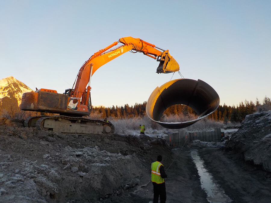
CRWP is soliciting proposals from qualified firms or teams to provide design–build services for the Little Tonsina ATV Trail Reroute, Culvert Removal, and Aquatic Habitat Restoration Project. The project is located near Richardson Highway Milepost 74 in the Little Tonsina area, and addresses a long-standing failing stream crossing, degraded aquatic habitat, and recurring ATV trail failures.
View/Download the full RFP here.
For questions or to submit proposals, email: Amy Scudder, Partnership Administrator, Copper River Watershed Project, partnership@copperriver.org.
Reference and Information:
The following legacy design plans and hydrology and hydraulics (H&H) report were developed during earlier phases of project planning and are provided for reference and informational purposes only. These materials are not intended to represent the final design, define quantities, establish costs, or limit proposer approaches. The data, assumptions, and analyses contained in these materials may not reflect current site conditions. Proposers should not rely on these documents as the starting point for design or cost development and are responsible for verifying site conditions and developing their own analyses and design solutions consistent with the requirements of this RFP.
For salmonids, access to healthy spawning and rearing habitats are important for maintaining high fish productivity. Certain species of salmonids can spend 2-4 years in freshwater using a variety of habitat types before smolting and migrating to the ocean. Resident species such as grayling can be very nomadic as well. Therefore, unimpeded movement through culverts is critical at all life stages to allow access to all habitat types. Poorly designed, installed, maintained and/or failed culverts can impede fish passage and limit connectivity of habitat, as well as decrease the quality and quantity of fish habitat for salmon and resident species alike.
 To learn more about the Copper River Watershed Project’s efforts to create a barrier free watershed and maximize habitat available to all aquatic organisms, including salmon, check out Program Director Kate Morse’s brown-bag presentation hosted by WISE. This presentation also provides an overview of our highest priority restoration project in the watershed, removing two culverts and installing a bridge over the Little Tonsina River and improving access to an estimated 70 miles of upstream habitat for Chinook and Coho Salmon. View the presentation here.

Download the Chutes and Fish Ladders game below for some fish passage fun!
Prioritizing Fish Passage Improvement Projects
Culvert Mapping Webpage »
The CRWP and partners recognize the importance of access to spawning and rearing habitats, but culvert replacement projects are very expensive and the ecological benefits can vary greatly from one stream to the next.
To help prioritize how to spend limited fish habitat restoration funds, CRWP has developed a protocol that assigns numerical values to culvert conditions (constriction, perch, velocity) and ecological conditions (i.e. fish presence/absence and quantity/quality of fish habitat) associated with road crossings.
 This scoring system generates a number score for each culvert and provides an objective ranking of potential fish passage improvement projects. This information helps partners identify the potential projects that have the most ecological benefit to the aquatic system and make the most of limited resources. This data has been integrated into an online mapping tool to provide a visual tool for interpreting the prioritization data and assisting with planning efforts.
We use this culvert prioritization protocol as a planning tool and for facilitating discussions with permitting agencies, property owners and land managers, and the Alaska Department of Transportation & Public Facilities.
For more information about scoring methodology and how to interpret scores, download our Culvert Prioritization document.
Current Fish Passage Projects
- REQUEST FOR PROPOSALS – Design-Build Services for the: Little Tonsina ATV Trail Reroute, Culvert Removal, and Aquatic Habitat Restoration Project.
- Eyak Lake Weir Replacement will be constructed in 2026-2027. We appreciate the continued partnership and support as this important community project moves closer to construction.
- Cop 3/Sher 3 culvert replacement project is coming this summer!

Successful Fish Passage Projects
Here are examples of culvert replacement projects completed by the CRWP and its partners in recent years.
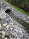
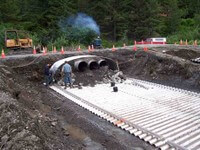
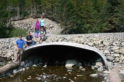
Little Tonsina, Milepost 74, Richardson Highway
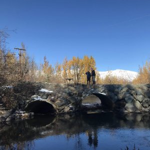
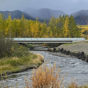
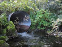
PROBLEM: Two undersized, damaged culverts blocked fish passage to seventy miles of upstream spawning and rearing habitat for coho and chinook salmon.
OUTCOME: A bridge was installed in 2023 spanning two times the bankfull channel keeping this high-priority spawning habitat flowing freely.
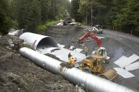
18 Mile Creek, Goose Meadow, MP 20.1 Copper River Highway


PROBLEM: The original pipe, lower middle in the photo, was 8′ in diameter and blocked passage to three miles of upstream habitat for juvenile coho salmon and cutthroat trout.
OUTCOME: Installed in December, 2016, this new 15′ 4″ x 10′ culvert is fish friendly! It accommodates the full width of the natural stream channel. Streambed material was placed inside the pipe to hold the base in place and to provide more natural stream conditions for fish passage.
Eccles Creek & Whiskey Creek
PROBLEM: In the 1980s, the Eccles Creek Bridge was replaced with an 8′ culvert for the 22′ wide Eccles Creek. From the waterline, the culvert was perched 6” and acted as a velocity barrier for rearing juveniles. ADF&G and USFWS agreed replacement would improve fish passage.
The Whiskey Creek culvert was under-sized for five-year peak flood levels, creating a velocity barrier for juvenile fish passage and resulted in flooding to neighbors’ property. Storm water runoff was a visible problem to many locals.
OUTCOME: Replaced Eccles & Whiskey Creek culverts and worked with community partners interested in stream routing to improve drainage and reduce sediment runoff. Improved access to quality habitat for coho, pinks, and cutthroat trout.
Power Creek Road, by old Ketchum air site
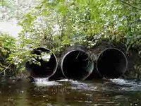
PROBLEM: Three small culverts were constricting the water flow from the upstream side of Power Creek Road and degrading the downstream gravel spawning beds.
OUTCOME: By replacing three 36″ culverts with one 15′ x 6′ arch pipe, allowing the full width of the stream channel to flow under the road, we improved spawning habitat for sockeye salmon and access to spawning habitat for pink salmon.