Copper River Fisheries – A Sustainable Industry
CORDOVA sits on the winding coast of Southcentral Alaska, where the majestic, snow-capped Chugach Mountains meet Prince William Sound and the Gulf of Alaska. Founded centuries ago as a fishing village, Cordova has always relied on Mother Nature’s gifts from the sea.
A world-famous salmon fishery (in addition to herring, halibut, shrimp, crab and many other fisheries) has developed in this tiny village of 2,500. Each May, hundreds of family-owned gillnet fishing boats leave Cordova’s harbor and set out for the wild ocean waters of the Gulf. It is there, near the mouth of the mighty Copper River, that the fishermen set their nets and carefully fish for the famous Copper River salmon.
Managed for Regeneration
The Copper River is famous the world over for the health of its salmon runs and the taste of its fish. This is thanks to carefully regulated fisheries that are managed by the Alaska Department of Fish & Game to guarantee salmon numbers large enough to reproduce and replenish the population.
Along the shores of the Copper River, there are sonar stations that count the fish, allowing fisheries managers to determine when and where fishermen will be allowed to set their gillnets.
Gillnet Fishing on the Copper River Flats – A Selective and Safe Method
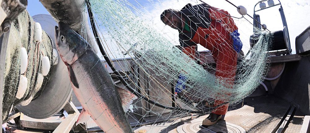
Copper River salmon are fished by local professionals using a method called gillnet fishing. As practiced in coastal waters in the United States, gillnetting is a selective, environmentally friendly method of providing highest quality fish to consumers.
This method of gillnetting is different from high-seas drift gillnetting, which has attracted negative publicity because of indiscriminate use of non-selective, catch-all nets.
Cordova’s Gillnet Fleet
Gillnets used in Cordova’s Copper River fisheries are limited to 900 feet (150 fathoms) in length. Their depth ranges from 20 feet for red salmon to 30 for silver salmon. They are “set” to intercept fish during their normal migrations, either along the shore or as they move in and out. All gillnet fishing takes place at the water’s surface and only drift gear is used.
The Cordova gillnet fleet is made up of smaller vessels, generally under 32 feet in length. Gillnetters use hydraulic net reels to set and haul their nets.
Selective Fishing with Little Bycatch
The size of the mesh in a gillnet, along with the fisherman’s intimate knowledge of the behavior of the fish he is seeking, guarantees that bycatch of other species will be minimized. Maximum mesh sizes – which are mandated in the management plans for each species sought – range from 5 inches for red salmon to 6 1/2 inches for silver salmon. Smaller fish generally swim through the mesh. Even when smaller fish or non-targeted species are caught, regular tending of the net by the fishermen ensures that many of them are released alive. This also guarantees that the fish that are retained are in excellent, ocean-fresh condition when they get to the market or table.
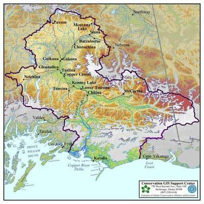
The Copper River Watershed
The Copper River watershed encompasses 26,500 square miles of mountains, river deltas, glaciers and wetlands, and is the third largest drainage in Alaska. Bounded in the north and west by the Alaska Range and Wrangell-St. Elias Mountains, the Copper River carves a deep path through the Chugach Mountains. The river deposits its silt load that creates the braided channels of the sprawling delta, as it enters the Gulf of Alaska.
Want to learn more about the Copper River? Check out Alaska’s Copper River Delta, by Riki Ott.
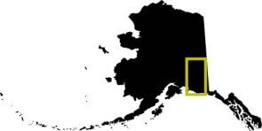
Above: The Copper River watershed, (yellow outline) is located in south central Alaska.
About the Watershed
- 26,500 square miles, with headwaters draining from Copper Glacier in the Wrangell Mountains
- Encompases Wrangell-St. Elias National Park, the largest National Park and Preserve in the U.S.
- Includes the Copper, Gulkana, Klutina, Chitina, Tazlina, Gakona and Tonsina Rivers along with hundreds of tributaries, lakes and smaller rivers
- Diverse wildlife habitat for bears, caribou, moose, mountain goats, sheep, wolves, waterfowl and many other species
- One of the last intact watersheds in North America
- Critical spawning habitat for three species of wild salmon that are the foundation of our ecosystem, culture and economy
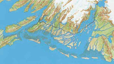
This map shows the Copper River watershed region, including the basin and the delta.
***Special thanks to the Conservation GIS Support Center and the Eyak Preservation Council for the use of the map.
The map below is an artistic rendering of the Copper River delta with its glaciers, mountains and waterways. You can see how the delta is made up of braided rivers and channels. The delta’s braided rivers and channels shift constantly as the Copper River deposits its silt load. The thin black line indicates the Copper River Highway, tracing part of the former railroad route.