Q&A with Ashley Taylor, CRWP’s GIS Specialist
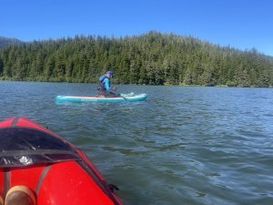
Ashley Taylor using GIS to map Coho spawning beds in Eyak Lake, Cordova. Photo by Nelly Hand
November 19, 2025, is GIS Day – a day dedicated to sharing, teaching, and inspiring others with GIS. The Copper River Watershed Project is lucky to have GIS Specialist Ashley Taylor on the team, and we want to take a moment to highlight the excellent work she does for our organization.
What is GIS? Google describes it well as a computer-based system for capturing, storing, managing, and analyzing geographical data to visualize and understand patterns and relationships on Earth’s surface. It combines geography and technology to create interactive maps that link spatial data with tabular information, enabling powerful analysis.
Sounds like a lot, right? But we’ve seen GIS in action here at the Copper River Watershed Project, and it’s a fun, essential tool for mapping culverts for fish passage and spawning beds for salmon, and for creating interactive story maps that break down large amounts of yearly data into easy-to-read visuals.
We did a short Q&A with Ashley to learn more about what she does and why she chose this work.
What is GIS for people who aren’t familiar with it?
AT: GIS stands for Geographic Information System (GIS)! Formally, it is a technology that people use to create, manage, analyze, and map all types of data.
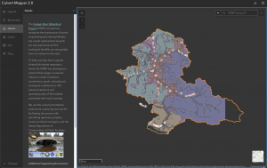
Culvert mapper for the Copper River Watershed
Why is GIS important to the work CRWP does in the Copper River region?
AT: CRWP uses GIS across all programs and projects in the Copper River region. We share information spatially with maps such as our Eyak Lake Atlas. We teach geographic interpretation and data visualization with our education programs. We collect stream temperature data tied to coordinates so we can contribute to regional work to identify cold water refugia for salmon. We update our Culvert Mapper database, which helps us continue to prioritize and secure fish passage funding for the highest-priority stream crossings with the worst culverts. We track the spread and treatment of invasive plants across the region and have GIS-based public forms for community members to report infestations. We even turned our annual meeting presentation into a Story Map, a multimedia, interactive GIS tool. GIS and maps are integral to the work we do at CRWP and help us communicate, share, and engage folks in our work, which can be challenging to do when working across such a large, complex region.

Maps page from the Eyak Lake Atlas
What drew you to pursue GIS as a career, and/or what inspires you about working with GIS?
AT: I’ve always been a visual learner and a lover of maps as communication tools. My undergraduate degree is in geography and environmental studies, as I really enjoy understanding how space and place are influenced by landscape. After college, my first job was almost entirely field-based mapping western monarch butterflies and their host plant, milkweed. In that role, I got to work with GIS professionals who opened my eyes to the powerhouse that GIS technology is. I went back to school and completed an advanced GIS certificate program, and then my master’s degree in GIS as well. I’m drawn to GIS for its versatility in environmental work. I think of it as a generalist tool that can be applied to a vast range of disciplines, which I think makes it a really useful skill/technology to be familiar with. Please reach out if you’re interested in GIS and mapping. I’m always happy to talk!
Have fun exploring the maps Ashley created!